Morgan Momentos – The Last Remaining Gillespie Buildings
At long last and as promised, I am now convinced that there is not just one but there are indeed two remaining buildings from the great T. A. Gillespie Loading Company facility which used to occupy a huge portion of Morgan. There are a number of previous postings made on this web site about the Gillespie plant and there are a number of them still in work. A different page on this Morgan-NJ.org web site shows what most thought to be the lone remaining building, located in Brown’s Boat Yard, which used to be part of the power plant. On the northwest side of that building in Brown’s Boat Yard are the remains of walls from the rest of the power plant. Along the docks are the crumbled remains of brick walls as well. We should all be grateful to Brown’s Boat Yard for retaining an almost lost part of Morgan history by, unlike Mr. Gorbachev, not tearing down the walls. I know I am appreciative!
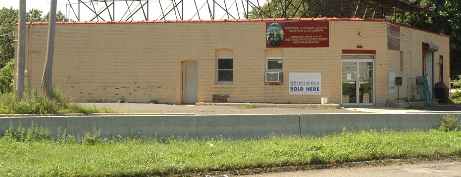
After a lot of research and greatly aided by the amazing Joyce Elyea with a dash of Randy Gabrielan and Ken Durrua, I feel very comfortable now making the claim that there is indeed one other remaining building left from the World War I era “Morgan Plant.” Interestingly enough, this is a building which I had passed by countless times as a child and, sadly, never noticed except that it was at a strange approximately 45 degree angle to the road. Other than the strange angle of the building, there are few clues when looking just at the front of it.
Here are the reasons I have come to this conclusion:
- I very closely examined all of the buildings shown on the various Gillespie plant layout diagrams I have and compared them to current maps and aerial photos. I also drove around Morgan during the occasional times I have been able to be there. There were a few buildings I thought might have been part of the Gillespie plant: the brick industrial building on the north side of Ernston Road near the top of the hill, some houses on Dolan Avenue, and four small bungalows just off of Route 35 south near Old Spye Road. After further examination, I now don’t believe they are.
- A while ago, Joyce told me of a building she had been told was a Gillespie building. According to Joyce: “Mr. Kali owned a business called Materials International back in the 1980s. I worked for an insurance agency in Woodbridge, and we wrote the policy for Materials International. Mr. Kali always came in person to pay his premiums. Seeing his business was in Morgan and I grew up there, I mentioned this to him. It was at that point that he told me his building was one from the Gillespie plant. He said the walls were about a foot thick.”
- Randy forwarded me an article from New Brunswick’s “The Daily Home News” from October 7, 1968 which shows a building next to a major cement road. Route 35 was originally a cement road and was still a cement surface in 1968. The building in the photo is at the same angle as the present day building, and states that that building was “The only intact building found today at the site of the T. A. Gillespie shell loading plant in…” I know of no other buildings along Route 35 which were at this strange angle.
- If present day South Pine Avenue continued straight, instead of curving to intersect with Route 35, the angle of the building would align perfectly with it. In fact, in 1918 the road now known as South Pine Avenue did continue straight all the way to present day Lorraine Avenue.

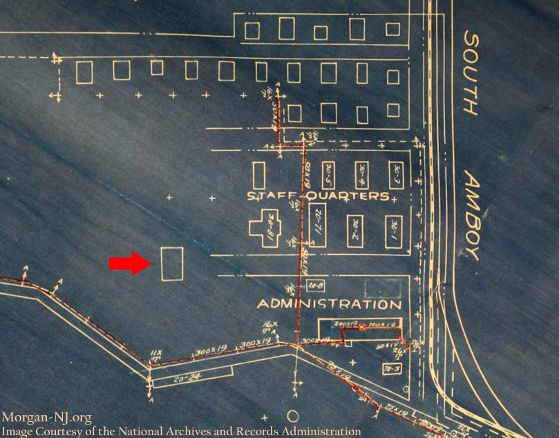
Blueprint from the T. A. Gillespie Loading Company Showing the Location of One of Only Two Remaining Buildings.
- There is an unlabeled building on the blueprint image of T. A. Gillespie buildings (see red arrow), which corresponds to the exact location and angle of the current day building. The problem is that the blueprint shows a rectangular building while aerial photos show the current building as being almost square.
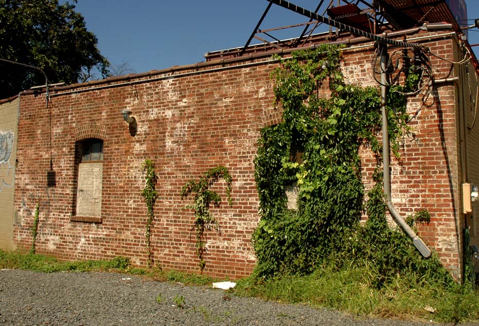
- The sides of the building facing Route 35 have a kind of painted yellowish brick facade surface as opposed to the natural brick color which is still present at the remains of the Power Plant walls at Brown’s Boat Yard. However if you look at the back of the building and a patch of one of the walls where the façade brick came off, you will see the same type and color bricks as is found at Brown’s Boat Yard.
- Looking closely at the brick part of the back of the building, you can see that the top of the frame of the windows used the exact same type of brick placement, three arched rows, as was used for the wall at Brown’s Boat Yard.
- The most important detail which clinched it for me was when I was allowed a look inside the building and saw that the southwestern half of the building was actually an extension. You can also see this when looking where the natural bricks end in the back of the building. Ken points out that the addition of the extension can be seen by viewing HistoricAerials.com. You can see on the maps that the extension occurred between 1957 and 1963.

The Original Brick Back Wall of One of Only Two Remaining Buildings from the T. A. Gillespie Loading Company.
- And finally, you can really see by looking inside the building that the original south western brick wall is still there!
The building is located on the southbound side of Route 35 just before the exit onto Ernston Road / Lorraine Avenue.
Originally posted on July 17, 2012.

Today I received a copy of my Great-Grandfather’s WWI draft registration (Lee M. Seely), dated September 12, 1918, indicating that he was working at this plant just weeks before this terrible explosion.
Fortunately for our family, he survived.
Thank you for the blue print image that shows the street information listed on his registration form. Your site brings to life once again this dramatic incident in the life of my Great-Grandfather, Lee M. Seely.
yup, this is a survivor of the plant, as stated before an ol timer from SA took us kids on a tour in 1986 or so and pointed outthe remaining buikdings and entrances and exits of plant, BTW rt 35 did’nt even exist in 1918